


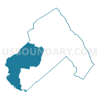
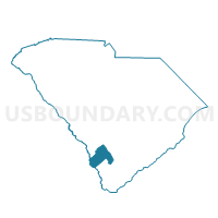
Estill Voting District, Hampton County, South Carolina
About
Outline

Summary
| Unique Area Identifier | 666001 |
| Name | Estill Voting District |
| County | Hampton County |
| State | South Carolina |
| Area (square miles) | 128.15 |
| Land Area (square miles) | 126.53 |
| Water Area (square miles) | 1.62 |
| % of Land Area | 98.74 |
| % of Water Area | 1.26 |
| Latitude of the Internal Point | 32.71915920 |
| Longtitude of the Internal Point | -81.30320280 |
Maps

Graphs
Select a template below for downloading or customizing gragh for Estill Voting District, Hampton County, South Carolina


Neighbors
Neighoring Voting District (by Name) Neighboring Voting District on the Map
- 1033B - 3B Voting District, Effingham County, GA
- 25103 - NEWINGTON Voting District, Screven County, GA
- 25111 - JACKSON FIRE STATION Voting District, Screven County, GA
- Black Creek Voting District, Hampton County, SC
- Bonnett Voting District, Hampton County, SC
- Fairfax No. 2 Voting District, Allendale County, SC
- Furman Voting District, Hampton County, SC
- Garnett Voting District, Hampton County, SC
- Gifford Voting District, Hampton County, SC
- Hopewell Voting District, Hampton County, SC
- Scotia Voting District, Hampton County, SC
Top 10 Neighboring County Subdivision (by Population) Neighboring County Subdivision on the Map
- Sylvania CCD, Screven County, GA (8,266)
- Estill CCD, Hampton County, SC (6,590)
- Fairfax CCD, Allendale County, SC (4,200)
- Shawnee CCD, Effingham County, GA (3,212)
- Newington CCD, Screven County, GA (2,608)
- Furman-Scotia CCD, Hampton County, SC (1,986)
Top 10 Neighboring Place (by Population) Neighboring Place on the Map
Top 10 Neighboring Unified School District (by Population) Neighboring Unified School District on the Map
- Effingham County School District, GA (52,250)
- Screven County School District, GA (14,593)
- Hampton School District 1, SC (13,703)
- Allendale County School District, SC (10,419)
- Hampton School District 2, SC (7,387)
Top 10 Neighboring State Legislative District Lower Chamber (by Population) Neighboring State Legislative District Lower Chamber on the Map
- State House District 157, GA (49,943)
- State House District 122, SC (35,907)
- State House District 120, SC (33,404)
- State House District 91, SC (30,470)
Top 10 Neighboring State Legislative District Upper Chamber (by Population) Neighboring State Legislative District Upper Chamber on the Map
- State Senate District 4, GA (182,797)
- State Senate District 23, GA (153,242)
- State Senate District 45, SC (92,424)
- State Senate District 39, SC (88,126)
- State Senate District 40, SC (86,132)
Top 10 Neighboring 111th Congressional District (by Population) Neighboring 111th Congressional District on the Map
Top 10 Neighboring Census Tract (by Population) Neighboring Census Tract on the Map
- Census Tract 9204, Hampton County, SC (6,590)
- Census Tract 9704, Screven County, GA (4,794)
- Census Tract 9704, Allendale County, SC (4,200)
- Census Tract 301, Effingham County, GA (3,212)
- Census Tract 9705, Screven County, GA (2,608)
- Census Tract 9205, Hampton County, SC (1,986)
Top 10 Neighboring 5-Digit ZIP Code Tabulation Area (by Population) Neighboring 5-Digit ZIP Code Tabulation Area on the Map
- 30467, GA (12,600)
- 29918, SC (5,278)
- 29924, SC (4,331)
- 31303, GA (1,999)
- 30446, GA (1,357)
- 29922, SC (1,214)
- 29923, SC (392)
- 29939, SC (302)
- 29932, SC (269)
- 29921, SC (227)